
Water meadows of Wessex
- ericawheeler18159
- Aug 5, 2025
- 9 min read
The word water meadows sounds so pastoral, so idyllic, cool on a summers day, grazing cattle, green hay with a slow, sparkling stretch of water. And they are and yet they were also one of the largest, most ambitious, most profitable and labour-intensive engineering works in Britain. And they are a distinctive, if difficult to see, part of the Wessex landscape – for the chalk streams that are so ubiquitous of Wiltshire, Dorset, Hampshire and the Isle of Wight are the very thing that give the water meadows their agricultural advantage. Water meadows were created and maintained, from the 1600s to the turn of the twentieth century, along the side of nearly all the chalk stream rivers of the area – the Avon, Wylye, Nadder, Piddle, Frome, Itchen, Test, Cerne, Anton and others. They were a vast improvement to farming and profit for the landowners, making them one of the biggest contributors to Britain’s ‘revolutions’ - agricultural and industrial. But how did they work? And where can you see them now? These massive, extensive, revolutionary, engineering works that are concealed beneath the turf of Wessex.
The first reference to water meadows is at Puddletown, Dorset in 1629, in the manor court “a great debate beinge theare had and questions moved by some of the tenants about wateringe and improving thiere grounds” it was agreed to create water meadows. Water meadows are a little more than just wet meadows – they are earth engineering works created alongside a river, in a river floodplain. The earthworks, or bedworks as they are known, create a system of banks, water courses and drains in order to flow river water, or ‘float’ the meadow, in a specific and very efficient way. They look a bit like large-scale corrugated iron on a field, but when working they also have water flowing along the top, spilling down the sides and along the bottom of the corrugations. Before the advent of fertilisers it was a way of improving the output of meadows.
The way the system worked was that you ‘floated’ the meadow in mid-winter, by opening a hatch, or sluice, to let river water into your water meadow. The water would run through your carrier channel, and be taken along channels along the top of your ridges, to overspill, and run down the ‘panes’ or sides, in a constant, shallow flow – it needed to keep moving to make sure it was oxygenated water and didn’t kill the plant life. The surface of each meadow had to be carefully prepared with ridges and drains, so that the surface could be covered with a thin sheet of moving water coming ‘on at a trot and off at a gallop’ . As it reached the bottom it would flow off back to the carrier and eventually to the river. The reason for doing it in winter was to start your grass growing earlier in the year than it would with no water. Chalk stream water in particular, comes out of the chalk a constant temperature of between around 10 and 12 degrees Celsius. Flowing this relatively warm water over the meadows would start grass growing perhaps in February, providing winter food for sheep. It was called an ‘early bite’.

The sheep would be fed on the water meadows in the day and be folded on the higher downs, or valley sides, at night. Thus their dung and urine would fertilise the arable land, which being on chalk was naturally low in nutrients. Corn could then be grown here. When the weather was warmer, perhaps May, the sheep were taken off the water meadows to the Downs permanently. The meadow floated again, this time to grow longer grass, which could be cut for hay – either to keep for winter feed or to sell in a centre such as Salisbury where plenty of hay was needed for the horses that worked the stagecoaches.
Perhaps later still in the year cattle were allowed onto the meadows, but their hooves tended to destroy the system if it was too wet. The whole of the system improved yields maybe three fold – bringing two or three crops where they might have been one. So, beautiful as it sounds it was part of a capitalist, land-owning, profit-making business and changed the landscape hugely in the early modern period. Great and expensive works had to take place, financed by a landowner with capital, and certainly initially disadvantaging commoners and common rights. It was a form of enclosure and agricultural improvement. The new dung-fertilised fields alone, encroached on former common downland. A great example is given in an article by Joseph Bettey (found here http://downtonvillage.co.uk/meadows.php) detailing the challenges, expenses and work involved at Downton on the river Avon. It shows how the extensive water meadow system between Salisbury and Downton was executed with finance from Sir Joseph Ashe, of New Court House and project managed by his steward John Snow. Snow explains:
“Firste, That there wilbe a greater increase of hay by wateringe of meadows & Knowne by common experience. Hay beinge plenty men may keepe the more cattle whereby their ground may be much bettered and ymproved. Theyre ground being thus bettered and ymproved there wilbe a greater increase of corne and the after grasse of their grounds thus ymproved wilbe of greate benefitt for the feedinge of cattle both to fatt and also for butter and cheese.”
Sir Ashe provided the finance and John Snow, the hard work, determination (and one might say ruthlessness and obsession) to see it through. It was a vast project involving: contracts and agreements with tenants, landowners, mill owners (who also needed the water) and commoners who would be affected by the digging of the carrier stream; big building works of carrier channels, hatches and bridges over difficult, boggy land on a fast flowing river and vast but precisely-surveyed landscaping in the meadows themselves. John Snow had to believe strongly in the eventual advantages of the system. Several times he had to justify the project to his employer and the extra expense. Here he lays out the improvement so far, nine years into the project, in 1674:
“Brewers Farm 74 acres of meadow previously worth £74 per annum now worth £148 per annum
Witherington Farm 50 acres of meadow previously worth £20 per annum now worth £100 per annum
New Court Farm 70 acres of meadow previously worth £80 per annum now worth £180 per annum.”
However, the challenges and expense continued for many years. In 1677 Sir Joseph Ashe wrote to John Snow ‘I thinke this cursed wateringe hath given me 10 tymes the trouble that all the other concernes of my life hath done’.
Snow had his boss to contend with on one hand and the people of Downton, who he had to trample over to get his project off the ground (as it were), on the other. A complainant of April 1682 complained that Snow ‘will allwaies be fidling in something for his private gaine and incroaching to break our customs as much as it lieth in him to doe ... He cares not the wrong he does in this kind’.

The profit from this agricultural improvement went on to feed the industrial acceleration of the country. The water meadows themselves, however, were no longer needed once cheap fertilisers and food imports were used and most are now abandoned. If you know where to look and what to look for you may just see their remnants. You can see that corrugation in the riverside fields and perhaps some brick work indicating a bridge or a sluice over a carrier. If you think of all the chalk streams and their valleys in the Wessex chalk and limestone areas and imagine that nearly all the of these were ‘improved’ with water meadows, by agreement of landowners and tenant farmers, you begin to see the scale of this engineering works - perhaps the biggest landscape engineering project ever in the country. When you look at a map of chalk river you often see several streams of the river running roughly parallel. Some of these are natural but many are leftover carriers for water meadows.
There are places to visit where you can still see some of this landscape heritage of Wessex. Top of the list has to be Harnham Water meadows in Salisbury. They are still flooded each year in January and February, you can go and see them open the hatches and let the water flow. There is a trust which maintains them, and undertakes educational work with schools and others. Their website tells you when the 'floatinhg' events are happening https://www.salisburywatermeadows.org.uk/
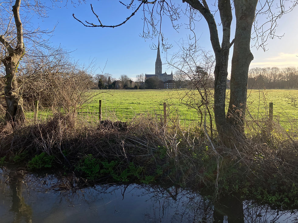


They sit where the Nadder and Avon meet. At other times you can walk across them on the town path: walk along Crane Street in Salisbury to Elizabeth Gardens and take the Town Path to the Old Mill (beautiful old building in itself) and you will see the corrugations as well as the rivers (of course these rivers are also excellent for mills, but that’s a post for another day).
The Avon valley is wide and flat and if you travel south of Salisbury you reach Downton, on the Avon. The water meadows were created all the way along the river from Salisbury to Downton, but here you can see them, the corrugations are really strong. You can take the road Long Close, off the A338 main road, then turn into Gravel Close. When you reach New Court House (one of Sir Joseph Ashe’s houses), turn right for a walk across the water meadows and back to the village.

In Hampshire, near Winchester are the Twyford Meads. These are also partially restored and you can see some of the brick work over the channels. Walk from Twyford village (parking at Berry lane) to Compton Lock, walking over the meadows.

Climb St. Catherine’s Hill, topped with an iron-age hillfort, to the south-east of the city of Winchester and look down on the ancient almshouses of St Cross. But also the corrugations and silvery light of carriers on the water meadows at the foot of the hill.

William Cobbett on his Rural Rides of the 1820s describes the whole Itchen valley being ‘watered’ and the city of Winchester:
"This vale of Itchen is worthy of particular attention. There are few spots in England more fertile or more pleasant; and none I believe more healthy. Following the bed of the river, or, rather, the middle of the vale, it is about five-and-twenty miles in length, from Ropley Dean to the village of Stouth Stoneham, which is just above Southampton. The average width of the meadows is, I should think, a hundred rods at the least; and if I am right in this conjecture, the vale contains about five thousand acres of meadows, large part of which is regularly watered. The sides of the vale are, until you come down to within about six or eight miles of Southampton, hills or rising grounds of chalk, covered more or less thickly with loam...; for a considerable part of the way the corn-lands are excellent, and the farm houses, to which these lands belong, are for the greater part under covert of hills on the edge of the valley...The fertility of this vale, and of the surrounding country, is best proved by the fact, that, besides the town of Alresford and Southampton, there are seventeen villages, each having its parish church, upon its borders. When we consider these things we are not surprised that a spot, situated about half way down this vale should have been chosen for the building of a city, or that that city should have been for a great number of years a place of residence for the Kings of England"
In Wiltshire, north of Salisbury, the Woodford valley follows the Avon and also has well preserved water meadows, although these are less accessible to the public.

There are visible remains of water meadows around Dorchester, very close to where the first ones were laid out, on the river Frome and Piddle. You can walk out from the town across Grey’s Bridge and turn right to see some. There are others to the North, walking out from Glyde Path Road and turning at Hangman’s cottage. And more visible from the A35 Dorchester ringroad.

Once you get your eye in you spot them in many places, especially when you have an inkling where you’re going to find them. At a recent visit to Upper Clatford on the Anton (which feeds into the Test in Hampshire) I thought I spotted the undulations between the river and the church.


Comments